Translations:Einzugsgebietsfenster/8/en: Unterschied zwischen den Versionen
Keine Bearbeitungszusammenfassung |
Keine Bearbeitungszusammenfassung |
||
| Zeile 1: | Zeile 1: | ||
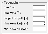
[[Datei:Einzugsgebietsfenster Topographie_EN.PNG|right]]The data to be entered in the Topography section is typically determined in a GIS. The area of the sub-basin is crucial for the amount of generated runoff, since the precipitation is processed into the Precipitation-Runoff-Modell as precipitation height [mm] and, therefore, has to be scaled with the area. | [[Datei:Einzugsgebietsfenster Topographie_EN.PNG|right]]The data to be entered in the Topography section is typically determined in a GIS. The area of the sub-basin is crucial for the amount of generated runoff, since the precipitation is processed into the Precipitation-Runoff-Modell as precipitation height [mm] and, therefore, has to be scaled with the area. | ||
The degree of imperviousness dictates the percentage of impervious area in the sub-basin and describes the proportion that runs off as urban surface runoff. The urban surface runoff is [[Special:MyLanguage/Einzugsgebiet#Oberflächenwasservorrat (versiegelter Flächenanteil)|calculated]] separately from the remaining natural surface runoff and retained in a separate [[Special:MyLanguage/Einzugsgebiet#Abflusskonzentration|storage cascade]]. The [[Special:MyLanguage/Einzugsgebietsfenster#Ablaufzuordnung|discharge | The degree of imperviousness dictates the percentage of impervious area in the sub-basin and describes the proportion that runs off as urban surface runoff. The urban surface runoff is [[Special:MyLanguage/Einzugsgebiet#Oberflächenwasservorrat (versiegelter Flächenanteil)|calculated]] separately from the remaining natural surface runoff and retained in a separate [[Special:MyLanguage/Einzugsgebiet#Abflusskonzentration|storage cascade]]. The [[Special:MyLanguage/Einzugsgebietsfenster#Ablaufzuordnung|discharge sequence assignment]] can also be used to assign this runoff to a different outflow element. | ||
The | The values for longest flowpath and maximum and minimum elevation are used to automatically calculate the [[Special:MyLanguage/#retention--oberflächenabfluss|surface runoff retention constants]]. | ||
Version vom 15. Dezember 2020, 10:46 Uhr
The data to be entered in the Topography section is typically determined in a GIS. The area of the sub-basin is crucial for the amount of generated runoff, since the precipitation is processed into the Precipitation-Runoff-Modell as precipitation height [mm] and, therefore, has to be scaled with the area.
The degree of imperviousness dictates the percentage of impervious area in the sub-basin and describes the proportion that runs off as urban surface runoff. The urban surface runoff is calculated separately from the remaining natural surface runoff and retained in a separate storage cascade. The discharge sequence assignment can also be used to assign this runoff to a different outflow element. The values for longest flowpath and maximum and minimum elevation are used to automatically calculate the surface runoff retention constants.
