Einsatzmöglichkeiten von Talsim-NG: Unterschied zwischen den Versionen
(fix translate tag not containing all content) |
(Diese Seite wurde zum Übersetzen freigegeben) |
||
| (Eine dazwischenliegende Version desselben Benutzers wird nicht angezeigt) | |||
| Zeile 24: | Zeile 24: | ||
* Berechnung aussagekräftiger Kenngrößen (Bilanzen oder Sicherheiten) | * Berechnung aussagekräftiger Kenngrößen (Bilanzen oder Sicherheiten) | ||
====Process-based hydrological modelling==== <!--T:6--> | |||
====Process-based hydrological modelling==== | |||
<!--T:4--> | <!--T:4--> | ||
| Zeile 59: | Zeile 58: | ||
</gallery> | </gallery> | ||
<!--T:7--> | |||
====Atmosphere / Vegetation / Soil Interface for Crop Water Requirements and Irrigation==== | ====Atmosphere / Vegetation / Soil Interface for Crop Water Requirements and Irrigation==== | ||
[[Einzugsgebiet]] | [[Einzugsgebiet]] | ||
<!--T:8--> | |||
====Linkage of flow components==== | ====Linkage of flow components==== | ||
[[Datei:Linkage of flow components.png|800px|center]] | [[Datei:Linkage of flow components.png|800px|center]] | ||
| Zeile 68: | Zeile 69: | ||
* Surface flow accumulates from element to element | * Surface flow accumulates from element to element | ||
<!--T:9--> | |||
====Nested modelling==== | ====Nested modelling==== | ||
A model within a model! | A model within a model! | ||
<!--T:10--> | |||
If necessary, sub-basins can be simulated with different resolutions and levels of detail within a large river basin model. | If necessary, sub-basins can be simulated with different resolutions and levels of detail within a large river basin model. | ||
[[Datei:Nested modelling.png|800px|center]] | [[Datei:Nested modelling.png|800px|center]] | ||
<!--T:11--> | |||
====Crop water requirements==== | ====Crop water requirements==== | ||
Comparison CropWat (FAO) vs. Talsim-NG | Comparison CropWat (FAO) vs. Talsim-NG | ||
[[Datei:Crop water requirements.png|800px|center]] | [[Datei:Crop water requirements.png|800px|center]] | ||
<!--T:12--> | |||
====Hybrid hydrological / hydraulic modelling==== | ====Hybrid hydrological / hydraulic modelling==== | ||
[[Datei:Hybrid hydrological and hydraulic modelling.png|800px|center]] | [[Datei:Hybrid hydrological and hydraulic modelling.png|800px|center]] | ||
<!--T:13--> | |||
====Water quality and stratification modelling==== | ====Water quality and stratification modelling==== | ||
[[Datei:Water quality and stratification modelling.png|800px|center]] | [[Datei:Water quality and stratification modelling.png|800px|center]] | ||
<!--T:14--> | |||
====Talsim-NG in operational mode==== | ====Talsim-NG in operational mode==== | ||
Automation from data retrieval to sending e-mails when operational simulation runs are required | Automation from data retrieval to sending e-mails when operational simulation runs are required | ||
[[Datei:Talsim-NG in operational mode.png|800px|center]] | [[Datei:Talsim-NG in operational mode.png|800px|center]] | ||
<!--T:15--> | |||
====Client-Server environment==== | ====Client-Server environment==== | ||
[[Datei:Client-Server environment.png|800px|center]] | [[Datei:Client-Server environment.png|800px|center]] | ||
<!--T:16--> | |||
====Emulated Client-Server environment==== | ====Emulated Client-Server environment==== | ||
Emulated client-server environment | Emulated client-server environment | ||
| Zeile 96: | Zeile 105: | ||
[[Datei:Emulated Client-Server environment.png|800px|center]] | [[Datei:Emulated Client-Server environment.png|800px|center]] | ||
<!--T:17--> | |||
====Participatory modelling / serious gaming==== | ====Participatory modelling / serious gaming==== | ||
Talsim-NG as tool for capacity building:<br> | Talsim-NG as tool for capacity building:<br> | ||
<!--T:18--> | |||
1) Topic: Live interaction between water managers<br> | 1) Topic: Live interaction between water managers<br> | ||
2) Tool: Put operators in various positions | 2) Tool: Put operators in various positions | ||
Aktuelle Version vom 26. Januar 2024, 12:22 Uhr
Talsim-NG stellt für viele verschiedene Aufgabenstellungen das passende Werkzeug dar:
- Niederschlag-Abfluss-Simulation (sowohl Hochwasser als auch Langzeitszenarien)
- Flussgebietsmodellierung und -bewirtschaftung
- Bewirtschaftung von Speichern, Hochwasserrückhaltebecken, Talsperren bzw. Talsperrensystemen für verschiedene Nutzungen (Wasserversorgung, Hochwasserschutz, Niedrigwasseraufhöhung, Energiegewinnung, Einhaltung von Mindestabgaben, Freizeitnutzung)
- Wassergüteberechnung
- Kopplung von Wassermengen- und Wassergütebetrachtung
- Dimensionierung wasserwirtschaftlicher Anlagen
- Operationeller Einsatz von Talsim-NG für den wasserwirtschaftlichen Betrieb in Verbindung mit einem Monitoringsystem
Ebenso stellt Talsim-NG für viele wasserwirtschaftliche Untersuchungen die passenden Funktionalitäten bereit:
- Interne Zeitreihenverwaltung
- Verwaltung der Simulationen inklusive der Ergebnisse zur Gegenüberstellung
- Langzeitsimulation / Kurzfristprognosen
- Beliebige Anforderung und Ausgabe von Zustandsgrößen
- Berechnung aussagekräftiger Kenngrößen (Bilanzen oder Sicherheiten)
Process-based hydrological modelling
Processes and features:
- Precipitation-runoff component + snow compaction
- Soil moisture and crop water requirements calculation
- Up to 6 soil layers
- Snow simulation
- Hybrid hydrological/hydraulic flood routing
- Non-linear atmosphere-vegetation-soil interface
- Hybrid hydrological/hydraulic flood routing,
- Hydraulic modelling of weirs, diversions, pipes
- Crop water requirements
- Irrigation
- Reservoir operation
- Water quality
- Hydropower
- Conceptual groundwater modelling
- Nested modelling of sub-basins with high spatial resolution
- Generic rule builder for water management options
- Pre-processing and post-processing
- Multicriteria optimization
- Time series manager
- Project and scenario manager
- Client-Server architecture
Gridded or watershed oriented approach
Talsim-NG can be used for both gridded or watershed oriented concepts
Atmosphere / Vegetation / Soil Interface for Crop Water Requirements and Irrigation
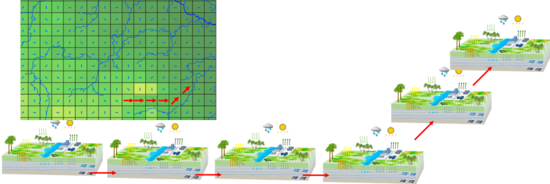
Linkage of flow components
Surface and sub-surface flow components between elements are interconnected. If soil downstream is saturated, flow from the upstream cell is impeded:
- Backwater effects
- Surface flow accumulates from element to element
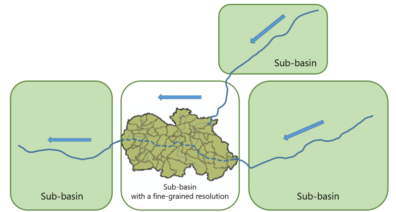
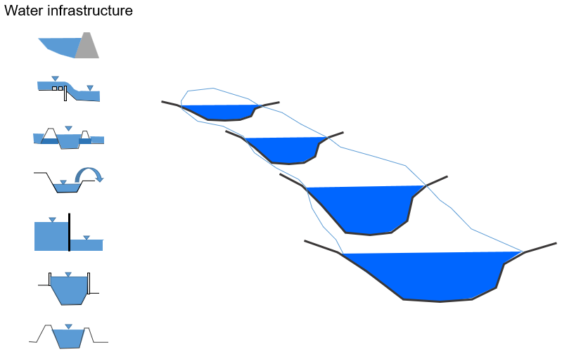
Nested modelling
A model within a model!
If necessary, sub-basins can be simulated with different resolutions and levels of detail within a large river basin model.
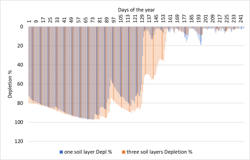
Crop water requirements
Comparison CropWat (FAO) vs. Talsim-NG
Hybrid hydrological / hydraulic modelling
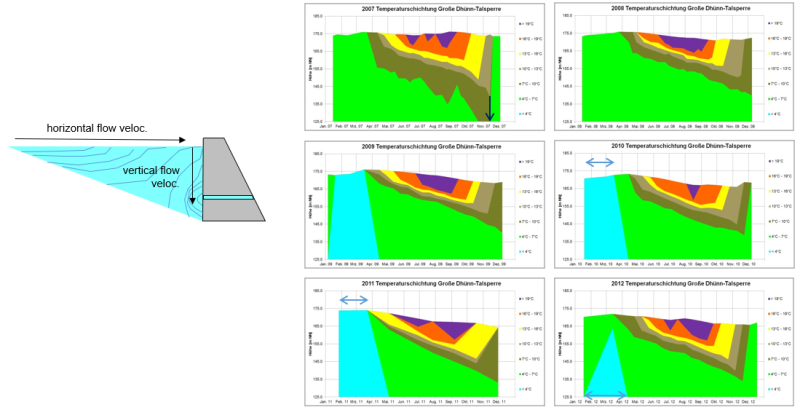
Water quality and stratification modelling
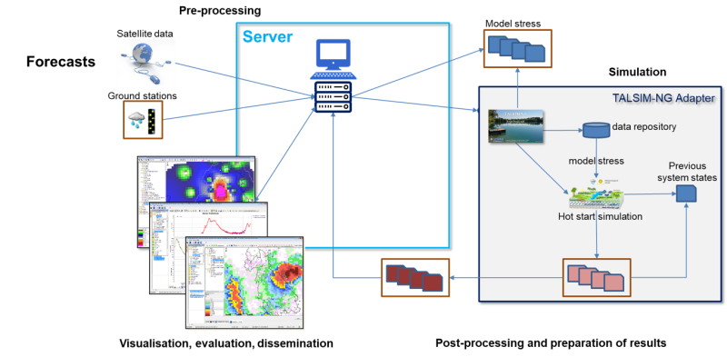
Talsim-NG in operational mode
Automation from data retrieval to sending e-mails when operational simulation runs are required
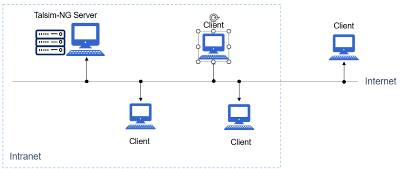
Client-Server environment
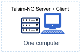
Emulated Client-Server environment
Emulated client-server environment Client and Server run on the same computer
Participatory modelling / serious gaming
Talsim-NG as tool for capacity building:
1) Topic: Live interaction between water managers
2) Tool: Put operators in various positions
- upstream perspective, downstream perspective
- exposes stakeholders to different levels of dependencies
- shows effects with/without data sharing
- demonstrates effects with/without cooperation
- mimics flood / drought events
3) Activity: A group of water managers plays at the same time
